
Road Trip in Tasmania
/After a fantastic 8-day, 1,400-kilometer road trip around Tasmania, Australia, I have a lot to document! Here’s a longer-than-usual writeup and pictures.
After Bundaberg (and the Down Under Rally), Brisbane, and the Gold Coast, I decided my next destination would be the island-state of Tasmania, including the city of Hobart which is famous in sailing circles because of the annual Sydney-Hobart race.
On November 19, I checked out of the Meriton Suites Herschel Street hotel, and made the very easy transit to the Brisbane airport: a 5-minute walk to the Roma Street Station from my hotel, and then a 15-minute train ride on the Airtrain.
The flight from Brisbane to Hobart was three hours, which reminded me that Australia is a big country! It would be impossible to see the country in a meaningful way on a single visit. I was happy with my baby-step, limited-scope approach; in my case, on this 4-week trip, I was just sticking to the eastern coastal areas of Brisbane, Tasmania, and Sydney. I would spend a full week in Tasmania alone.
Upon landing at the Hobart airport, I found my way to the EuropCar rental desk and picked up the keys to my rental car. One of the best decisions of the trip (thanks to my older brother for the advice) was to include a GPS unit with the rental. It was pricey – an additional $15 per day – but the GPS unit made navigating Tasmania much easier.
The rental process was easy, and within minutes I was on the road in my mid-size SUV. I headed to Cradle Mountain, where I had booked a room online at Discovery Parks.
I made the four-hour drive with only a quick stop for groceries. I was on a tight timetable for two reasons. First, I wanted to arrive before the Discovery Parks front desk closed. Second, and perhaps more importantly, I did not want to be driving in dusk or dark; animals are everywhere, and so is roadkill. I had been warned that it’s best to drive during the day to minimize the chance of hitting an animal, many of which are nocturnal.
The Discovery Parks was more “campground” than “hotel,” but they did have a few cabins with a shared bathroom. I checked in, and organized my backpack for my hike the next day. I then headed down the road to a fancy hotel which happened to have one of the only restaurants nearby.
The next day, I walked down to the Cradle Mountain Visitor Center (conveniently located across the street from Discovery Parks) at 8:00am. After buying a National Park pass, I boarded the first bus which took me to the trailhead. For the next 8 hours, I made the trek across the plains, through snow, over boulders, almost to the summit of Cradle Mountain, and then back along the face of Cradle Mountain, down to the lake, and back to the bus. It was an amazing trek.
The trail was very well maintained. The summit included some major bouldering. I couldn’t make it quite to the top because the snow and ice made it too slippery and dangerous. In some cases, it was impossible to tell whether the snow was solid, or if it was hiding a crevasse. I turned around, as did the four other hikers ahead and behind me. Even without making the summit, I got some fabulous views of the lakes and rock outcroppings, and definitely got a workout!
That night I enjoyed another dinner at the nice restaurant, and reflected on the day and my plans. When I booked my 3-night stay at Discovery Parks a few days ago online, I had really no idea what to expect. After today’s mega-hike, I felt that I had really seen enough of the Cradle Mountain area. I was eager to get on the road again and see what else Tasmania has to offer.
So, the next morning, I canceled the third night, checked out, and hit the road. The Discovery Parks office was nice enough to offer me a ‘credit’ for a future stay. I accepted, even though I knew that I’d probably never redeem it.
My plan today was to drive from Cradle Mountain to Port Arthur. The GPS unit indicated the drive would be 5-6 hours; but I took a scenic route which turned the trip into 7-8 hours. I drove down the west side of Lake Mackintosh, making a rest stop in the old mining town of Queenstown. I continued on toward Hobart, foregoing highly-rated Walls of Jerusalem National Park and Lake St. Clair to the north and Franklin-Gordon Wild Rivers National Park to the south. I stayed north of Hobart, until finally heading south to the Tasman Peninsula and the town of Port Arthur.
I arrived in Port Arthur just before the office at Stewarts Bay Lodge closed. I picked up the keys to my cabin, and went down to check it out. My cabin was huge, with a full kitchen and living room, washer/dryer, and nice balcony with a view. I took a quick walk on the beach to stretch my legs, and then headed to the nearby restaurant for dinner.
I spent the next day at the Port Arthur Historic Site. I walked around on my own first, then took the guided walking tour (which included a short boat ride to Isle of the Dead – a small island offshore where convicts, guards, and other residents were buried). Port Arthur has a very interesting history as a penal colony, as well as a tragic episode in modern times (a mass shooting happened here in the late 1990s).
In the afternoon, I took a quick trip up to the Coal Mine Historic Site, which had more prison ruins. The mine itself was a bit disappointing: the vent shaft is still intact, but the main entry shaft is filled in. The nearby rock quarry was interesting, though, and there are some scenic footpaths along the coast and in the forest.
That evening, I dined in the restaurant on the Port Arthur Historic Site and then took the “Ghost Tour” (which turned out to be a bit silly – I do not recommend). However, the restaurant staff was very nice to me (or felt sorry for a lone traveler), giving me the coveted corner table overlooking the entire site. Thanks!
Tasmania is famous for breathtaking, rugged coastline. The multi-day “Three Capes Track” is one way to see it. Rather than sign up for a tour and commit dollars and days, I decided to explore some of the track on my own.
Based on a recommendation from Stewarts Bay Lodge, I headed to Cape Hauy first. The posted walking time was 4 hours, but I completed it in 3 hours. The trail does not go all the way out to the end of the cape, but the viewpoints are dramatic, including views of the Totem Pole and Candlestick rock features.
Next, I drove to the Remarkable Cave. This quick-visit site includes a short 15-minute walk down to the viewing platform, about 10 feet above the beachy cove, where you can look straight through the tunnel in the rock and watch the waves as they roll in. It’s a neat spot, and worth a visit if you’re in the area. (You can’t actually get down to the beach to explore the cave, and depending on the tide, you probably wouldn’t want to anyway.)
I still had most of the afternoon ahead of me, so I decided to drive to the trailhead at Cape Raoul. The sign indicated a roundtrip walking time of 6 hours. Hmm. I didn’t want to be hiking at 7:00pm, but I also knew (from previous hikes) that if it says “6 hours,” I could probably do it in 5 hours or less. I decided to go for it.
The hike was long, indeed, but totally worth it. The trail leads all the way to the end of the Cape – or at least as far as any reasonable person would want to go – and wow it is awesome! The “Cape Viewpoint” is actually not the best view in my opinion. It is hard to see the Cape when you are standing on top of it. Instead, I recommend going to the “Seal Viewpoint” just 10-minutes off the main trail. This will give you a nice view back at the Cape, where you can see the cool pinnacle type rock formations.
Both capes were quite windy. At Cape Raoul, things got pretty exciting when a squall came in fast and passed overhead. I think I have some good Go Pro footage as I stay low in the protection of the brush out on the cape, trying to make it quickly into the more dense cover of the forest.
I managed to complete the hike in less than 5 hours. But, as indicated, I walked pretty fast on the return trip (and I didn’t spend as much time as I would have liked to at the viewpoints). I would recommend allowing yourself the full 6 hours.
Back at Stewarts Bay Lodge, I dined in the restaurant and planned the next couple of days.
I woke up early the next morning, checked out, and drove to Triabunna where I caught the first ferry to Maria Island. This little island has quite a bit to offer: a penal colony, old residences, fossil cliffs, the famous Painted Cliffs, and lots of wildlife! There is quite a bit of history around the families and business ventures that were established (or were at least attempted) on the island. I spent most of the day here, before taking the afternoon ferry back to Triabunna.
I spent the night in the small beach town of Swansea, based on the recommendation of a hiking guide I had met on Cape Hauy. The town proved to be a good staging area for a visit to Freycinet National Park, which was my next destination.
The next morning, I made the 20-minute drive from Swansea to Freycinet National Park. Here, I took a long walk to Wineglass Bay Beach and Hazards Beach. I would have liked to spend the night here, but instead, I had to make the drive back to Hobart that afternoon. The days were ticking by quickly, and I wanted to make sure I had time for Hobart and Sydney.
Thanks to GPS again, I found my way back to the Hobart Airport and returned the car. The bus from the airport to central Hobart was very convenient. I checked into the Quest Waterfront Serviced Apartments, and still had time for a quick walk before dinner.
I spent the next day wandering around the streets of Hobart, including taking a treasure-hunt type tour of sculptures situated in historic spots around the town. The sculptures referenced particular periods or features of Hobart’s history. After my walk, I quenched my thirst at The Whaler pub. In the evening, I dined at Suzie Luck’s restaurant and tried a whiskey at The Salamanca Whiskey Bar.
The following day was Wednesday, so I headed to the Museum of Old and New Art (MONA). Rather than explain this place here, I encourage you to read about it online here. It’s pretty unique, and definitely worth a visit. (Check the opening hours – I discovered it’s closed on Tuesdays!)
I spent four hours in MONA, but still felt rushed due to the confusing layout, dim lighting, and crowds (especially at the popular exhibits). The technology is pretty cool – you’re given a handheld device that detects what exhibit you are nearest and gives you text and audio (via headphones) about that exhibit. For the popular exhibits, you use the device like a restaurant buzzer – you register your place in line and then you’re buzzed when your time has come. Some wait times were 30-45 minutes, so plan accordingly!
Also, a paper map of MONA would also be helpful, but the museum staff said they “ran out.” You might consider trying to find one online before your visit (and save as PDF on phone) so you can plan a route through the hallways, tunnels, and ‘secret’ rooms.
After my visit to MONA, I took the museum’s private and uniquely-themed ferry back to town, and then caught the bus to the airport. I flew to Sydney where the final part of my Australian adventure would begin…

Across the plains, on my way to Cradle Mountain, Tasmania, Australia.

To the summit!

This is as far as I could go — just a few hundred yards from the summit. The snow and ice made it too dangerous to proceed. The other four hikers with me also turned around.

Even here, though, the view was stunning.

Heading back down from the summit.

Phew! At the bus pick-up point, looking back at Cradle Mountain. A long 8-hour hike!

Port Arthur, Tasmania, Australia. (A former penal colony.)
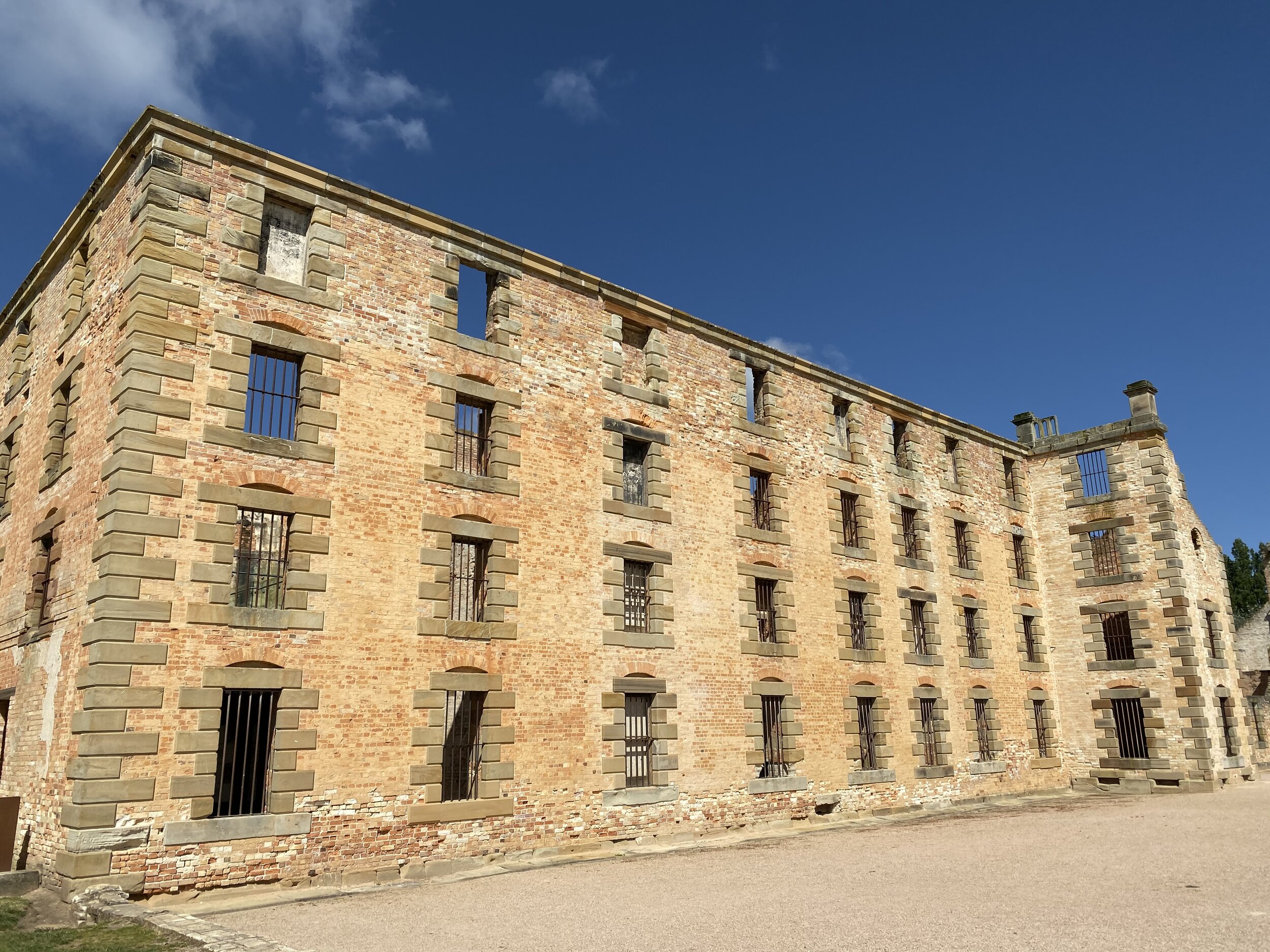
The main cell block.

The cell block at the Coal Mines Historic Site, just a few miles from Port Arthur.

On the “Ghost Tour” at Port Arthur Historic Site. Here the tour guide is showing us a “ghost”.

Cape Hauy. This is as far as the trail goes; so you don’t actually make it all the way out to the end of the Cape. But the view is breathtaking. Rock features Totem Pole and Candlestick can be seen from here.

The Remarkable Cave. They say that if you angle it just right, the view through the cave outlines the sorta upside-down triangle shape of Tasmania, hence, it’s Remarkable. This picture doesn’t quite do it, but if you imagine taking a few steps to the left, the upper white light part of the cave will be the shape of Tasmania.

On my way out to Cape Raoul. A 6-hour hike, but well worth it!

This is the view from Seal Viewpoint. The Cape Viewpoint isn’t as good because you’re actually standing out on the Cape, so it’s harder to see the neat rock formations.

The famous Painted Cliffs on Maria Island, Tasmania, Australia.

Wineglass Bay (and Beach) in Freycinet National Park. This picture is taken from the Viewpoint.

Hazards Beach, across the Isthmus from Wineglass Bay Beach.

In Hobart, I followed this ‘treasure hunt’ self-guided tour. Pretty fun way to see some of the historic sites and learn about Hobart.

An example of one of the ‘treasures’ on the tour. This highlights the high-quality sandstone that Tasmania is famous for.

The cool private ferry to the Museum of Old and New Art.

One of the exhibits at MONA. This is a room full of motor oil. You walk into this trench, and stand quietly, looking at the reflection of the checkered walls in the motor oil. Don’t lean over, and hang onto your phone!